
Monday, October 31, 2011
Tornado Trees
Friday, October 28, 2011
Happy Halloween

Two of the granddaughters came over the other night to carve pumpkins, so I shamelessly highjacked one of them to pose this picture. With the jack-o-lantern is my solo decked Superior Expedition canoe, the 280-cm twin-blade Bending Branches Slice Glass solo canoe paddle, and the Bending Branches bent shaft BB Special. Yes, I plan to get them wet (not the pumpkin) any day now. Enjoy the season. jim
Monday, October 24, 2011
Birch Bark Canoes
I came across a seven video series done by Ray Mears for BBC TV. Working with an Algonquin canoe builder, they built a birch bark canoe in 9 days from raw materials and basic hand tools. I think you'll find it informative, interesting, and with the humorous banter between them as they work, just plain entertaining to watch. Total viewing time is about 45 min. This link connects you to the first of the series, and you can follow one to the next. The second link is just a view at a series of bark canoes.
http://www.youtube.com/watch?v=c1J1-bup-7s
http://www.youtube.com/watch?v=c1J1-bup-7s
Friday, October 21, 2011
From Worse to Worser

Canton Lake yesterday.
This picture was taken by a lady that lives near the lake. The Corps says the lake is down 58%. The Corps has released the water to supplement reservoirs in Oklahoma City, which also looks like this. There was a question for a while as to whether they would in fact do the release, because they said it would take a week for the water to reach Oklahoma City. During that time, half of the water would be lost to absorption and evaporation.
While we were at Kaw Lake, we could actually see the water level dropping every day as it receded from the shoreline. At the time, the water level was listed at -5%. It is now at minus 6%, so the rain we had last week (the first measurable amount we've had in the last year) has done nothing to help the lakes. To feel better, we have to look at Meredith Lake, which shows a level of minus 106%.
Wednesday, October 19, 2011
The Last Guide

Photo credit: AbeBooks.com
The Last Guide: A Story of Fish and Love, by Ron Corbett (230 pp., 2001, pub by Viking, the Penguin Group, Toronto, Ontario, Canada)Ron Corbett, a columnist and feature writer for the Ottawa Citizen, met Frank Kuiack (pron. Kwe-ack) while in Algonquin Park area doing an article on wolves. In the wilderness where Frank was raised, there were few opportunities for employment. There was a chance to work felling trees for the lumber company, being a cook in a lumbering camp, working on road crews, but little chance for a real paycheck until he found a job in the mines 2,800 feet below ground. He was making more money than his Dad ever had. One day after some time off, he was returning to work. He had his ticket and sat on his duffel on the platform waiting for the bus. Later in life he would say “there are few moments of true clarity in life,” but that was one of them. He changed his bus ticket and returned to the wilderness. He’d become a full-time fishing guide.
Over the years he would gain a reputation for being one of the best. His clients returned year after year. His regulars were such people as E.B. White, author of Stuart Little and Charlotte’s Web, trumpeter Al Hirt, who was so big he had to lie in the bottom of the canoe when fishing, Michael Landon, Dan Blocker, and Lorne Greene, nearly the whole cast of Bonanza, and wealthy corporate execs and professionals. Even executives from Germany, Holland, and the rest of Europe, had his home phone number and would call him of an evening to book trips. Frank knew every lake and every hole where a fish could be found. The book takes you canoeing through streams and lakes, talks fishing, has you setting up camp and spending evenings around the campfire, tells you the lore and history of the area, how it changed over the years, and about not just Frank, but several other guides as well. The fishing guide business in Algonquin nearly died in 1979 when motors where banned from boats on the lakes. Most guides quit or moved on, but Frank had rowed or paddled his clients most of the time anyhow, so he hung on. The Last Guide takes you by canoe for some of the nicest memories, and some of the biggest fish. It’s a wonderful read.
Sunday, October 16, 2011
The Snipping Tool

I spent about four hours learning how to use the Snipping Tool to better illustrate my posts. It took a dozen tries, but I finally got through the process and finished with a map. This was Day 4 from the Kaw Lake Trip. As you can see from the map, they indeed showed the channel into the Arkansas River entering the lake from the East shore, when changes in the channel now have it along the West shore. This is not a work of art, but with work, I hope to improve. I also added it to the original Day 4 post if you want to go back and see if it makes the description of the trip any clearer.
Saturday, October 15, 2011
Black Spruce Journals
Photo credit: Barnes and Noble
Tales of Canoe-Tripping in the Maine Woods, The Boreal Spruce Forests of Northern Canada, and the Barren Grounds by Stewart Coffin (183pp., 2007, pub by Heron Dance Press, Williston, VT)
That’s probably the longest subtitle I’ve ever seen, but it describes his travels over a lifetime. His story spans the period from when he was introduced to canoe/camping by his father and then as a Boy Scout until, at age 77, he felt it was time to chronicle his travels. Mr. Coffin signed up for a whitewater canoeing course in 1954, one of the first such programs in the country. Through whitewater training, he met Jane, his wife, who was as passionate a paddler as himself. They began their travels through the Maine streams and lakes using a paddling guide published in 1935. It was apparently the first such guide ever done, was difficult to find, as only 500 copies had been published, and was in dire need of up-dating. Through their memberships in the Appalachian Mountain Club they began to scout every lake and stream, first in New England, and then beyond, to do write-ups for a new and more comprehensive paddling guide. The book is chocked full of personal experiences, good and bad, about old guides, canoe builders and paddle makers, his experiences as one of the first in the country to venture into fiberglass canoe construction, his work in nature photography, and the rivers, islands, and bays he explored in the Canadian provinces and territories. One of his goals was to never travel a river more than once, but to keep moving on to new territory. Occasionally, however, he would retrace his steps while working as a guide for other tripping parties, or when a section of river would be used again when it became part of another route, but he covered a tremendous amount of country.
Thursday, October 13, 2011
Killarney
I've spent all week just trying to drag myself around with a miserable cold. I haven't even felt like reading for more than a half-hour at a time. If you're still in good enough health to enjoy a good book, here's another one to relax with from the Paddlers' Reading List.
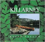
Killarney by Kevin Callan (84pp., Stoddart Pub. Co., Toronto, Canada, 1990/94)
Any paddler will of course immediately recognize Kevin Callan’s name from his videos, speaking tours, and numerous books. This book is more a soft-bound coffee table book about the Killarney Provincial Park that sits just above Georgian Bay, at the north end of Lake Huron. The many photos that accompany the text show the beauty of the area in full color, except those from historical records, which are in black and white or sepia (a brownish tint that, you may find interesting to know, came from the excretion of cuttlefish). At the end of the book, for those who may want to turn daydreams into reality, are seven canoe routes through the area via lakes, rivers, bays, and some portages. Both the history of the area and the unique beauty will draw you in. In fact, the author said he had misgivings about doing the book. Making one of his secret, special places public would only mean more and more people would beat a path to his secret haven.
Monday, October 10, 2011
Moving Waters

Photo Credit: eBay
Early in the book is one of the best written descriptions of the angst he feels before the start of every such trip. He thought for some time it was unique to him, that maybe there was something wrong with him. Why would he feel such deep guilt for trying to do something he enjoys? Some honest discussions around the campfires revealed the feelings weren’t unique. He looked forward to the trip, enjoyed the preparation and anticipation, but also felt, even if his family preferred to stay at home because they didn’t share his enthusiasm, that he was being selfish. He knew he had earned the chance to pursue a personal interest, but still feared he was being unfair to his wife at home dealing with the daily routine or problems. The conflicts would even detract from the enjoyment of the trip, especially in the early stages before the daily challenges of survival demanded his attention. If you too have experienced this, you may appreciate his honest look at this problem.
Kaw Lake, Day 7
There was a nip in the air this morning, and sea smoke drifted across the lake. While we were having breakfast, the DJ on the local FM radio station was unwittingly doing a commentary on the Oklahoma public education system. I surely hope it’s one that’s undeserved. We sat there alternately laughing and shaking our heads. He claimed to be good at math, and was surprised at how many homework problems his daughter had gotten wrong. She insisted her solutions were correct, so he proceeded to explain the process of subtracting two numbers. He couldn’t remember what to do with the zeros in a minuend or larger number. He knew a zero had to be changed to ten, but never borrowed anything. By his description, 200 - 24 = 286. And he was on the radio explaining this process to thousands. Jean added that perhaps he should run for Congress. A lot of our politicians have problems with zeros too.

Back on February 5th, I described the U-Haul Universal One-Man Canoe Loader. I’ve had to abandon it in favor of a simpler, cheaper, and safer method of loading the canoe by myself. The theory behind the One-Man Canoe Loader was great, and it specifically addressed my problem of getting a heavy canoe on top of a very high truck cap and rack. It managed okay on the stripper Micmac canoe pictured in that article, but it fell short on application with the Superior Expedition. The pole had too much movement. The swivel bar would not hold the canoe in place, and several times spun around and dropped the canoe with its sharp rudder on the cap roof. I incorporated controlling and stabilizing lines, and before long the rigging of the canoe started taking a ridiculous amount of time. Now, I can load the canoe in a fraction of that time. I lay a doubled blanket across the rear of the cap roof. One end of the canoe’s bottom is propped against the blanketed roof. Grabbing the other end that is on the ground, I just shove the canoe up onto the rack as it slides on the blanket. I then climb up onto the tailgate, roll the canoe over so it rests on the cockpit coaming and tie it down.


The U-Haul Universal One-Man Canoe Loader
Sunday, October 9, 2011
Kaw Lake, Day 6-B
I continued north until I once again ran out of water. Gifford says the catfish are scarcer, but I found the north end of the lake lousy with them. The water was shallow enough their dorsal fins would cut through the water, or a large fish would explode from beneath the canoe in an eruption of water and a swirl of mud. When every stroke brought up slimy mud, I came about and headed south. When I got back to Gifford, he showed off the 5-lb cat he had caught during my absence, but added he had caught his largest right there about a year ago, a 35-pounder.
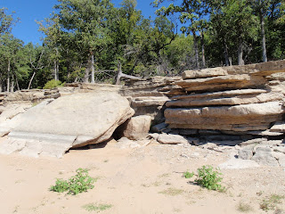
The hills are made up of layer upon layer upon layer of rock. As the erosion undermines it, the large outcroppings jut out in mid-air until they become unstable, or break off when they become fragile from their own tonnage, and down they crash. They break off in random sections, but some are large enough to park a car or pickup on.
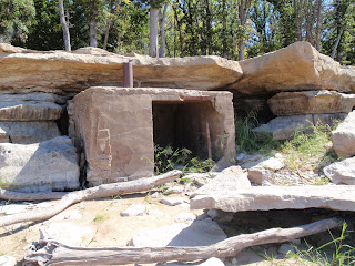
Continuing down the shore I found a square building constructed under a large outcropping. It cleared the overhang just enough for the chimney to pass in front of the cliff face. There had been a normal sized door, but one side of the cabin face had broken away enlarging the opening. It looked like walls had been set up in a form of cribbing, which was filled with rock and scraps of steel. Mortar was then worked into the cribbing from both sides and plastered smooth. Once a support was constructed, the cement for the roof was poured over a matrix of pieces of whatever steel the builder could find to use. I saw evidence of re-rod, steel cable, pipe, and flat stock. The roof was mounded slightly around the chimney to insure drainage off the roof. My imagination was screaming to suggest some old Indian had lived there with his pot-belly stovepipe running up through the heavy steel chimney. When I sought out a COE employee that had grown up here, however, he reported it had belonged to a farmer who lived in the valley below here before the lake was filled, and he had built it as a smokehouse.
I continued south down the lake, finally crossing the lake again and returning up the west shore to the campground. In all, it was 10.7 miles. I got far enough south that I was just north of the cape that separates Washunga Bay from the main lake.

Wild purple liatris. It is beautiful, but this really is a bad time of year to be
poking around tall grass and rocks. The poisonous snakes are blind during the
end of September and October. As they shed, their eye scales go opaque. They
are really ill-tempered (as I would be if my skin was peeling off), and will strike
at any sound or movement.
Friday, October 7, 2011
Kaw Lake, Day 6-A
It was 47 degrees this morning with a cloudless sky. It was one of those perfect autumn days with sunny, crystal clear air and miles of visibility. I launched Ibi and headed straight across the lake with a light chop on the port beam. When I reached the Eastern shore, I stopped to take a picture of the interesting limestone rock strata on shore.
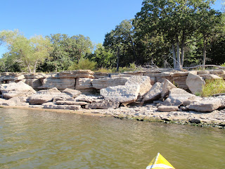
. Just as I took the picture, a movement up on the bank caught my eye. I looked up to see three white-trailed deer bounding up the hill and through the trees. Since it was just a day-paddle, I went without my usual gear, and the light boat had me running along at a steady 3 mph with an easy relaxed stroke with the Bending Branches Bent Shaft BB Special. I was seeing something about 2 or 3 miles up the lake that I couldn’t identify. It was a good distance into the lake from shore.

There was a splotch of white on the top and bottom and black in the middle---maybe pelicans or egrets on a couple stumps. When I closed with it, I discovered the white was two five-gallon buckets, one on the ground in front of an ATV and one perched on top. The ‘ground’ the ATV was on was a very long, skinny sand spit that ran well into the lake. Relaxed in his folding chair with two fishing poles was Gifford Kurtsick.
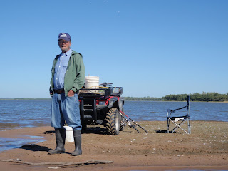
Gifford is one of those 81-year-old guys that looks 20 years younger. I nosed the canoe up onto the sandbar, and we proceeded to talk away for nearly an hour. He told me about being on a destroyer in the midst of the Korean War, up near the Manchurian border. The bow had been damaged and several men killed when the ship hit a mine.
The USS Ernest G. Small struck a mine 7 Oct. 51. Four days later the forward section broke off in heavy seas. She was steaming in reverse for Japan. I'm shocked to realize as I'm typing this, that today is the anniversary of the disaster.
Gifford has fished here on the lake for 20-some years and lives just over the hill. He fishes until it’s time to go home for lunch, takes a nap, then returns to fish some more.
Thursday, October 6, 2011
Kaw Lake, Day 5
Another windbound day. Winds are out of the north 25-35, gusting to 45. Whitecaps and rollers were sweeping down the lake. So, we visited the Chief Standing Bear Museum in Ponca City for several hours.


While this bison and calf are life-size, I'm afraid they're bronze.

Click photo to enlarge. An irony of the time was that while Native Americans
were being moved to free land for settlers, the settlers were free to move in among
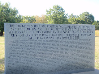
the Indians and settle on their assigned lands. The school, church, and cemetary
were along the west shore of the lake just south of the campground.
Wednesday, October 5, 2011
Kaw Lake, Day 4
Finally! I launched Ibi and paddled away from the ramp at 1020. Actually, it was more like poling, as the water was only 7” deep for the first 100-ft, making the ramp pretty much useless for anything but a kayak or canoe. The lake is down at least 5-ft according to water marks along the shore, which means I need to talk with someone at the Corps.

Obviously, I need schooling in interpreting their daily lake water level statistics. According to what I found on their site, the lake was supposed to be down 2 ft. Paddling the coves and feeder streams are what I enjoy most, since they are more picturesque, and that’s where you find the most wildlife. Since they are all dry, I tabled the idea of canoe-camping around the entire lake now in lieu of family time and a few day paddles. The wind helped reinforce that decision. When I first planned the trip, I had hoped to start from Arkansas City, just north of the Kansas state line, and follow the Arkansas River down to the lake. I called the town’s executive secretary to explain what I was doing and seek

guidance on the town’s launch sites. She said, “I wouldn’t recommend trying that. You’ll be extremely disappointed. Right now you could walk the Arkansas without getting your shoes wet. There’s grass and weeds where there should be water.” Instead, Plan B was to paddle from Kaw Lake up the Arkansas with the objective of reaching Trader’s Bend. Sometimes finding the feeder stream for a lake can be tricky, especially since I was holding two conflicting maps. One showed the river entering the lake along the west shore around a bunch of islands, and the other from along the east shore. As it turned out, I went up the west shore and ran right into it.

With the lake way down, there were also countless dead trees, stumps, and other obstructions to avoid running up onto. The river was shallow, seldom much more than a foot deep, and as little as eight inches. After a few miles, I rounded a bend, and the river suddenly broadened and flattened out. I ran aground a couple times trying to negotiate sandbars in search of a channel. Finally I got out and towed the canoe behind me as I walked 80-yds. back and forth across the river seeking a channel. Nothing! It was earlier than planned, but I had little recourse but to come about and head back down the river. I had bucked a decent headwind all the way up the lake and river, but found comfort in the prospect of riding the wind all the way back. The joke was on me. As soon as I came about, the wind died. In all I paddled 13.4 miles.

It was a great day, and plenty physical enough after several months of hibernation. My body was saying it may have been a bit much. You can say anything bad you want though, about the low lake, tree stumps everywhere, sandbars, shallows, but just being on the water always brings things to enjoy and appreciate---watching huge catfish leaping and darting from beneath the boat, pelicans gathering to begin their migration, the first hint of changing fall colors. Cool!


It's a long, long way to the water.

guidance on the town’s launch sites. She said, “I wouldn’t recommend trying that. You’ll be extremely disappointed. Right now you could walk the Arkansas without getting your shoes wet. There’s grass and weeds where there should be water.” Instead, Plan B was to paddle from Kaw Lake up the Arkansas with the objective of reaching Trader’s Bend. Sometimes finding the feeder stream for a lake can be tricky, especially since I was holding two conflicting maps. One showed the river entering the lake along the west shore around a bunch of islands, and the other from along the east shore. As it turned out, I went up the west shore and ran right into it.

With the water level down, the shores and coves were seeded
with millet by plane for the migratory waterfowl.

It was a great day, and plenty physical enough after several months of hibernation. My body was saying it may have been a bit much. You can say anything bad you want though, about the low lake, tree stumps everywhere, sandbars, shallows, but just being on the water always brings things to enjoy and appreciate---watching huge catfish leaping and darting from beneath the boat, pelicans gathering to begin their migration, the first hint of changing fall colors. Cool!

Tuesday, October 4, 2011
Kaw Lake, Day 3
It will not surprise those who know me, or regular readers of the blog, that some rather unusual things can latch onto my interest and attention. At Coon Creek Cove Campground, it was the restrooms. After doing the entry on May 26 about the EF-3 tornado that swept Canadian Campground at Canton Lake, I began to think a lot more about tornados in campgrounds. When you’re out in the middle of nowhere and a tornado is barreling down on you, where do you go? When the funnel went through Canton, six people ran into the shower stalls of the restrooms. The cinderblock walls collapsed, but all those inside survived. At the restrooms of Coon Creek, a Corps of Engineers camp, I found myself standing outside examining every square foot of the structure. The bottom was done in horizontal lapboard siding, and the top half was done in board and batten construction. The roof was covered in cedar shakes. That’s a bit different than the one shown here.

Then I knocked on the siding and realized everything was concrete, including the roof. It had all been molded in concrete to give it a natural appearance, but the thing was massive, and even attractive. When I looked inside, I saw the CXT Buildings, Hillsboro, TX, label over the door. I sought out a COE employee for more insight, and he said the buildings are reportedly supposed to withstand an EF-6 tornado or an earthquake. For you own peace of mind when camping or enjoying a picnic, you may wish to check out this site. http://cxtinc.com/

Today was hot and windy, so since another day would prove unfit for paddling, I sought to learn more about the local history. The valley that is now Kaw Lake was the site of Kaw City and the Native American town of Washunga. In talking to a lady born and raised here, she gave me this account of how the lake came about. The federal government condemned the land in preparation for a project designed for flood control along the Arkansas River, especially for Tulsa. The residents were offered $3,000 per household and required to vacate their homes. They could have their homes moved to higher ground where the new Kaw City would be, or leave them to be bulldozed. When asked during the public hearing what would happen if they refused to leave, they were told, “Then you’ll be swimming.” Apparently the only building they were unable to move or destroy was a five-story hotel being used as a retirement home. Trying to implode it with explosives failed, as did trying to reduce it with a wrecking ball. Finally the Rt. 11 bridge was built over what remained, and it still sits at the bottom of Kaw Lake. The dam is 11,000 ft. long and rises 121 feet above the riverbed. It creates a 38-mile-long lake with 168 miles of shoreline. The lake was filled in 1976. Another interesting sidebar is that the river that feeds the lake is known to everyone as the Arkansas River, except for those living in Kansas, to whom it is the AR-Kansas River.
Another lady, a Choctaw, told how Indian women were not allowed to conduct any business, being considered incompetent. Regardless how much money or land they had, they were required to have a white sponsor before they could either buy or sell. When her grandfather died, he left her grandmother a large farm with a good bit of land. To sell the farm to have money to live on, she had to marry a white man. He managed her business for her, stole everything she had, and left her with nothing.
Then I knocked on the siding and realized everything was concrete, including the roof. It had all been molded in concrete to give it a natural appearance, but the thing was massive, and even attractive. When I looked inside, I saw the CXT Buildings, Hillsboro, TX, label over the door. I sought out a COE employee for more insight, and he said the buildings are reportedly supposed to withstand an EF-6 tornado or an earthquake. For you own peace of mind when camping or enjoying a picnic, you may wish to check out this site. http://cxtinc.com/

Tomorrow will be a paddle day. Ibi takes a rest along the Eastern Shore of the lake.
Monday, October 3, 2011
Kaw Lake, Day 2
During the powwow last night, the MC broke into the program several times to give OU and OSU footfall score updates. The Cowboy is the OSU mascot, and I had to chuckle at what seemed an amusing historical reversal where hundreds of Indians sat around cheering on Cowboys. Regardless of race, however, if you live in Oklahoma, you’re a rabid football fan. I think it may be required by a part of the state constitution.
The Kaw are called “the wind people,” and their presence was evident from dinner last night through today. The wind was forecast 15-30 mph, but it blew 30 mph or better all night. It didn’t drop to about 20 until late afternoon today. I found no peace of mind from Judy, a campground caretaker, telling me about a 70-90 mph straight-line wind that blew a camper trailer off the cliff and into the lake. In short, it was not a paddling day.

The north end of the lake looks like a field covered with fresh snow from the thousands of pelicans settling into the lake during their migration. During the afternoon a fragment of the group floated down the lake by our campsite while feeding. To get out of the waves, a powerboat had tried to land on the beach below our site, but was sunk as large whitecaps rolled over the transom and swamped the boat. An organized effort by a couple men simultaneously lifting and bailing finally got the boat afloat before it was moved around to the boat ramp.

With the rest of the day open, we traveled to the Chief Standing Bear Museum. I think it important to reflect a moment on the significance of the Indian Territories and Chief Standing Bear. During the travel reports of Lewis and Clark, other expeditions by the French, Spanish, and the fur traders, the impression in Washington was that the portion of the Louisiana Purchase that would become the Indian Territories, was of little value to whites. Since it was also barren and open, it would make Indian activities and movements easy to observe. Indian control or eradication was debated for some time. Several issues would conspire to settle the issue. Forcing all the Native Americans here to Oklahoma would free richer lands then available for farming and settling by those continuing to press west and south. Under ever-growing pressure for their lands, and fearing the government would not honor its promises, several tribes in Georgia, Florida, Alabama, and Mississippi had gone to court to seek jurisdiction over their own lands. Then gold was found in the Cherokee lands of Georgia, and something had to be done about Indians competing for the buffalo herds. Congress passed the Indian Removal Act of 1830, and Pres. Andrew Jackson signed it into law. Over the next ten years, over 70,000 Native Americans would forcibly be driven from their lands and into the Indian Territories. The 14th Amendment says that “no person shall be deprived of life, liberty, or property without due process of law.” However, forced movement of these peoples from their homes and lands was considered legal and appropriate since Indians were not persons, or humans, and therefore did not fall under legal protection.
“The soldiers formed a line at one end of the village and drove the people like cattle before them. The 500-mile march was hardest on children, the old and sick.” Chief Standing Bear’s own daughter was one of the victims of the march. They arrived in the ’warm lands,” where the government promised to provide food, blankets, and implements to sustain them until they got established, since they had been unable to bring anything with them. The supplies never materialized, and the tribes faced famine. Between their arrival on July 9 and the end of the year, 158 of the 730 Poncas from one village that survived the march had died of pneumonia and malaria, including Standing Bear’s second child, his 12-year-old son. As his son lay dying, he asked his father to promise to return him to the land of his grandfathers for burial.
On a January night, Standing Bear and 29 others slipped away to carry the boy’s remains north. When they arrived, they were arrested as renegades and imprisoned without a trial. Two attorneys, one being chief counsel for the Union Pacific Railroad, filed a suit for a writ of habeas corpus on Standing Bear’s behalf. After a two-day trial in 1878, the judge ruled on Standing Bear’s behalf, and for the first time in U.S. history, Standing Bear had made it possible for an Indian to be considered “a person--a member of the human race.” To make sure it wasn’t a total victory, the Indian agent approached Standing Bear at the conclusion of the trial to inform he that since he was now a non-Indian, he could never again enter any Indian Territories, even for a visit. There is a lot of U.S. History that is never taught in public schools.
The Kaw are called “the wind people,” and their presence was evident from dinner last night through today. The wind was forecast 15-30 mph, but it blew 30 mph or better all night. It didn’t drop to about 20 until late afternoon today. I found no peace of mind from Judy, a campground caretaker, telling me about a 70-90 mph straight-line wind that blew a camper trailer off the cliff and into the lake. In short, it was not a paddling day.

A small band of pelicans drift by our camp while feeding.

The 22-ft. bronze statue of Chief Standing Bear.
Sunday, October 2, 2011
Kaw Lake, Day 1
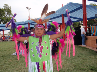
We just returned from a 431 mile road trip to Kaw Lake in North Central Oklahoma, east of Ponca City. We camped at Coon Creek Cove Campground (COE), which sits on a peninsula, or at least it is a peninsula when there is water. Today was dedicated to getting camp established and taking the two nearest granddaughters to the powwow at Standing Bear Native American Memorial Park in Ponca City. For those not familiar with powwows, they are a Native American gathering of tribes for council meetings, rituals, tribal and family reunions, dance competitions, and a celebration and passing-on of tribal culture and tradition.

Before becoming a state, Oklahoma was the Indian Territories to which 64 tribes from all over the country were forcibly removed. The word Okla-homa in fact means “Red Peoples.” With so much Native American culture based here, powwows run almost non-stop, somewhere in the area, from May through the end of September. While many people see such dances in tourist venues, there is nothing like seeing the real thing, and since they are mostly open to the public, it is the best opportunity for whites to begin to appreciate the rich Native American traditions. So, besides paddling, I’ll include some of what I’ve learned on this subject as well, and I hope you find it as interesting as I do. Besides, we inherited our paddling from the Indian peoples.
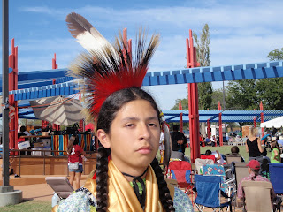
There were six tribes represented at the Kaw Nation powwow: Pawnee, Otoe-Missouria (originally of the Winnebago), Osage, Tonkawa, Kaw, and Ponca. They were all part of the Kanza or Kansa Nation, who gave their name to the Kansas River, also called the Kaw River, and the States of Kansas and Arkansas. The event is held in a circular arena with an inner circle 150 feet across. All spectators and tribal members sit around an outer ring. A group that seemed to vary between about 30-50 sat in the center of the arena to provide drumming and singing for the dances.
Because of the different tribal dialects, they use vocables in place of words so all can participate. There is a lead singer who starts, and then everyone joins in as the sound swells and dancers move into the arena either for several categories of dance competition, or huge inter-tribal dances. In the latter, you can see the heritage being passed to the next generations as four and five year olds join in the dance. By the time they are six or eight, they begin to appear with their own regalia.
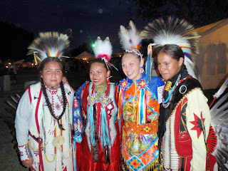
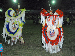
While the dance competitions had been going on all day, the formal ceremony and adult dances began at 7p.m. and continued until they were done. As the night goes on, the regalia become fancier and more colorful, and the dancing more strenuous and athletic. The awards ceremony is held when the competitions are complete, with one awards ceremony reportedly not being started until 4 a.m.
The winds conspired to keep me from meeting my expectations for paddling during the week, although you’ll see I got in a couple real nice days. The winds started this evening and it got cold. Finally, the youngest granddaughter wanted to get in my lap and cuddle to keep warm and sleep. I wrapped my arms around her to keep her from sliding off. I later got my report card---I’m nice and warm, but I squeeze too hard.
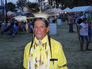

Frontal pictures taken with permission only.
Dance competitor's tribal regalia.


While the dance competitions had been going on all day, the formal ceremony and adult dances began at 7p.m. and continued until they were done. As the night goes on, the regalia become fancier and more colorful, and the dancing more strenuous and athletic. The awards ceremony is held when the competitions are complete, with one awards ceremony reportedly not being started until 4 a.m.


Subscribe to:
Posts (Atom)