Sunday, September 30, 2012

The Arkansas River - 4

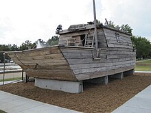
Flatboat
Photo credit: wikipedia
 
From 1800-1814, French fur traders established a healthy business by going up the river with whatever trade goods appealed to the native tribes, exchanging them for furs, which they brought south for shipment mainly to Europe. The age of the steamboat began to dawn about 1814. Until then, river cargo was handled mostly upstream by canoe or pirogues (hollowed out logs), and downstream in flatboats and keelboats. The latter two were temporary vessels intended to last only long enough to deliver the freight down river. They were then broken up for building materials or scrap.

Two keelboats, one being poled and one under sail, passing a flatboat.
Photo credit: wikipedia
 
Jean Pierre Chouteau and his brother Auguste (a graduate of the recently established West Point Military Academy), were French Creole fur traders, merchants, and later, politicians, who amassed both wealth and influence through the new Louisiana territory from New Orleans to St. Louis and west. As early as 1796, Jean Pierre had established an alliance with several thousand Osage that called for them to move to the Three Forks area to develop a fur trade there. In 1802, Jean Pierre established the first trading post and permanent white settlement along the Arkansas River in Oklahoma at the junction of the Neosho River (previously called the Grand River) and Saline Creek, which is now Salina, OK. Indians boiled water from a spring south of the post to obtain salt, and Chouteau obtained the salt springs in 1825 through a treaty with the Osage, and turned the property around in 1830 when he sold the springs to Sam Houston, a friend of Washington Irving. In 1819, Auguste Chouteau established a boatyard at the Three Forks, near Fort Gibson, or present-day Muskogee, OK. Boats from his yard were 50-60 feet long, and could carry 50 tons of freight.

I found a historical disagreement concerning the Chouteau’s. One source credits Jean Pierre with establishing Salina, another gives the credit to Auguste. I’m not a historian, but everything seems to say Jean Pierre was in the area first, so I’d lean his way. Since they were both eventually there and working together, it probably doesn’t make much difference. Also, there’s enough credit to go around. After all, it was their father, Rene A. Chouteau, who had founded St. Louis. Across the Neosho River from Salina, and a bit southwest, is the town of Chouteau, OK, also named for the brothers. It was originally a cattle town made prosperous by the Katy railroad starting in 1871, and called Cody Creek after a stream that flowed north of town. Both the name of the creek and the town were changed to Chouteau, again reflecting the wealth and influence the family was amassing along the upper Three Forks area. Jean Pierre’s son, August Pierre, called A.P., continued the family business in Salina and established another post along the Verdigris River and others along the Mississippi. His son, Pierre, who was called Cadet, continued the expanding business until around 1850, by which time the railroads had created a steady decline in river trade. He then moved to New York to diversify the family’s wealth into steamboats, railroads, and mining.


Saturday, September 29, 2012

The Arkansas River - 3

The further I dig into the history of the Arkansas River, the more interested I become. The navigable segment of the river ceases to be just a 444-mile stretch of water, but takes on character and personality. While it’s just a slight glimpse into the lives of those that came to and developed the lands along the river, I know the experience of paddling the river will become that much richer.


The attack on Arkansas Post on 11 Jan. 1863, by Union ironclads
and 33,000 infantry and cavalry.
Photo credit: encyclopediaofarkansas.net
 
In 1682, Henry de Tonty (or Henri de Tonti) became friendly with the Native Americans around the confluence of the Arkansas with the Mississippi, and built a fort he named “Poste Aux Arcansas,” the first white settlement in the Louisiana Territory, and which is now Arkansas Post. There were technically four Arkansas Posts, as the forts were moved about to positions more defensible from attack. An Arkansas State Park is now at the location of the original fort. The only skirmish of the Revolutionary War to occur west of the Mississippi, took place at Arkansas Post in 1783. In 1819, Arkansas Post would become the capital of the Arkansas Territory. Arkansas Post figured again in the Civil War when Fort Hindman was built there. Military operations from there were successful enough in disrupting Union communications and supply lines that it warranted a Union attack on January 11, 1863, as a prelude to the attack on Vicksburg. The Confederate forces were forced to surrender, and the fort was destroyed, unfortunately along with all remaining structures from the French and Spanish historical periods.

After the Revolutionary War, George Washington was especially concerned with the possibility of Britain, Spain and France trying to lay claims to the rivers and thus the surrounding lands in the Western Territories. He created what became the basis for our navigable waterway laws with the Ordinance of 1787. This stated that “the navigable waters leading into the Mississippi and the St. Lawrence shall be common highways and forever free, as well to the inhabitants of said territories as to the citizens of the United States, without any impost, tax, or duty.”


Thursday, September 27, 2012

The Arkansas River - 2

Hernando deSoto
1496-1542
Credit: wikipedia
 
The Arkansas River changes it face several times while it travels east-south-east from the Rockies. It drops an amazing 11,400 feet along its length, beginning as a torrent that falls 5,000 feet in its first 125 miles. It begins near the town of Leadville, Colorado, and runs its way through the major cities of Pueblo, CO; Wichita, KS; Tulsa, OK; and Fort Smith and Little Rock, AR.

The Arkansas River basin was a focal point for the exploration and development of the Plains region. Credit for finding the Arkansas and first naming it goes to Coronado, but the main reason is he kept better records to document his travels. Another famous name from the time was Hernando de Soto, who miraculously was in the same area the same year, 1541. They were in different areas of the Arkansas however. Coronado crossed the river near present Dodge City, KS, at a point commonly used by Native Americans and buffalo herds for fording the river . DeSoto followed the river south and crossed near present Arkansas Post, before again turning north in search of the Indian city of Coliqua near present Little Rock.

DeSoto had begun his expedition by landing at present day Shaw’s Point, Bradenton, Florida, in May 1539. Arriving with nine ships, he put 220 horses and 620 men ashore for an exploration north and west. By winter, they had reached the head of Apalachee Bay, and the area of the Aucilla and Ochlockonee Rivers. Archeological evidence has confirmed that the DeSoto expedition wintered-over about a mile east of present Tallahassee. In the spring, they continued into Georgia, the Carolinas, Alabama, Tennessee, Louisiana, Oklahoma, Mississippi, Arkansas, and Texas. On May 8,1541, deSoto’s men became the first Europeans to cross the Mississippi River near Memphis. He wintered along the Arkansas River. A year later, May 21, 1542, deSoto died from a fever on the west bank of the Mississippi River near McArthur, Arkansas. While his remains were never found, writings by members of the expedition indicate his remains are believed to be in Lake Chicot, at Lake Village, Arkansas. From a historical perspective, deSoto’s expedition is considered a failure. His documentation was weak, his men managed to spread disease among the native populations, and they created hostile relations with any Native Americans they encountered.


Monday, September 24, 2012

The Arkansas River

The Port of Catoosa, America's Most Inland Port
 
After getting sick on one trip, and having shoulder trouble on another, I swore I wouldn’t make projections, or predictions, about what trips I was going to do, but this is a definite trip already in the planning book.

The Arkansas River has 18 locks and dams, 5 in Oklahoma and 13 in Arkansas, that drop the river level 420 feet before it reaches the Mississippi River. This navigable portion is roughly 444 miles from Catoosa, OK, to the Mississippi. That leaves a mere 599 miles of the Mississippi remaining before reaching the Gulf. I’ll leave that segment for another trip. If you count the entire river from the Colorado snow pack, it is 1,469 miles long. The Arkansas River is one of the five largest rivers in the U.S., and the longest tributary of the Lower Mississippi.

The first accounts of the Arkansas River come from the expedition journals of Spanish conquistador and explorer, Francisco Vasquez de Coronado. He lead an expedition north from Mexico between 1540 and 1542, and traveled through what would become Arizona, New Mexico, Texas, Oklahoma, and Kansas. The force he lead included 400 Europeans, 4 Franciscan monks, and up to 2,000 Mexican Indian allies. When he reached the Arkansas, he named it the St. Peter and St. Paul River. That horribly lengthy miscarriage was corrected by early French traders that renamed it the Akansa, after the American Indian tribes that lived along the river.

After the 1819 Adams-Onis Treaty, the Arkansas River formed the boundary between the United States and Spanish Mexico. That border existed until the Mexican-American War of 1846 and the annexation of Texas. Later, the Santa Fe Trail ran west along the Arkansas River.

Through the 19th century, the Arkansas was rarely navigable above Fort Smith, Arkansas. During the 20th century, the water levels in the river continued to drop as water was drawn off by farmers along its course for irrigation purposes. To correct this problem, the creation of the McClellan-Kerr Arkansas River Navigation System opened the river to navigation to the Port of Catoosa, near Tulsa, OK, making it the most inland commercial port in the United States. The waterway, named after the two Democratic Senators, one each from Oklahoma and Arkansas, who worked to advance the proposal through Congress. The waterway was to include the lower portion of the Verdigris River, the Arkansas, and a short segment of the White River before its confluence with the Mississippi. Construction was begun in 1963 and the waterway opened to commercial traffic in 1971.


Thursday, September 20, 2012

St. Johns River Revisited

Manatee swimming in Blue Spring.
Photo credit: wikipedia
 
I have a couple other trips I’m looking at, but probably none require as much forethought as the St. Johns River. Part of it is because it’s so far away for me, and because conditions there change so quickly. I first planned to do the St. Johns during the latter part of 2010. If you’re interested in such a trip, I did reviews of the best two books on the subject in November and December of 2010---River of Lakes and the St. Johns River Guidebook. Both are interesting reads even if you do most of your paddling from an armchair. The St. Johns River Water Management District offered two pieces of advice that shaped my planning. The first was to do the trip between New Years and mid-March. Before this is hunting season when most of the camping sites are reserved, and after is when the bug population comes back to life and bull alligators get horny, mean, and fearless. However, it was a later bit of news that put the trip on hold. There had been so little rain in the upper river that it had dried out, and people were doing the river on ATV’s.

With a tropical storm and several heavy rain storms the last month or so, the upper river level is back up, and most of the conversation in the area has turned to fishing rather than drought, so I’ve dusted off the planning notebook. It’s actually quite a bit more involved than dusting off a file. I’ve had to pretty much go over everything. The entire trip has been run three times so far on paper to double check GPS positions, maps and charts, making changes to add new information and remove dated material. Then I ran the whole trip again to measure all distances between points. For planning purposes on the water, this helps improve decision-making near the end of the day to meet existing conditions. If it’s been a tough day, we may decide an earlier than planned stop is in order, or if we have a following wind and are feeling good, perhaps we may decide to pack in a few more miles. Knowing the distance to each potential stopping place is invaluable at that point. Getting caught out after dark on some reaches of the river is not an option.

The entire river from Blue Cypress Lake to the ocean inlet at Jacksonville Beach is 310 miles along the channel. However, I’d like to add a couple interesting side trips that are recommended as highlights of the experience, such as the Wekiva and Econlockhatchie Rivers, Jessup and Crescent Lakes, and Haw Creek at the bottom of Crescent Lake, which together total roughly 415 miles if we end the trip at Palatka. Continuing to the ocean would add another 80-90 miles.

The river is loaded with history. For example, Haw Creek is where the Confederates scuttled a couple ships to keep them from falling into the hands of Northern troops during the Civil War. They were raised after the war and put back in service, but seeing where such history took place is exciting. Also exciting is the opportunity to see areas that have changed little since Native American tribes lived along the river thousands of years ago. One author said that the St. Johns River is North America’s Amazon, and just as interesting.

All of this anticipation and excitement now has to remain on hold to see if there’s still water in the river in January.


Wednesday, September 12, 2012

Say It Like It Is!


Do you find yourself getting frustrated by all the things that get in the way of what you would really prefer to be doing? Does getting time on the water seem to be impossible to achieve, but thousands of other things pile on you like an avalanche? Does saying what’s on your mind seem impolite? Well, you don’t have to be Dr. John Becker to speak your mind, so put it out there!

CaféPress enables you to design your own shirts to suit your message. I was lucky enough to fall on a two-for-one sale, and was looking for a bright chartreuse safety shirt to use either paddling or biking for greater visibility. These arrived about an hour ago. Now can I be any clearer?


Monday, September 3, 2012

Kabloona

Cover photo credit: GoodReads.com
 
Kabloona, by Gontran de Poncins (Reynal & Hitchcock, Inc., New York, 1941, 339 pp.)

To answer the obvious question, kabloona is an Eskimo word for white man. The book was published in 1941 as a Book of the Month Club selection. It is about Poncins’ experiences when he went to spend a year with the Eskimos in the far North to study their language, culture, and customs. He began the book with an apology. He explained that this is a look basically into how our ancesters lived 20,000 years ago. How Eskimos live, and what they need to do to survive is beyond the understanding of soft Outsiders. The Outside is what Eskimos call the rest of the world. He feared some of the things he described might be found to be revolting, or shocking, but his explanations helped to put them into a light that, in the Eskimo’s context, made them logical and understandable. Some of the less bizarre things, the everyday things that we take so much for granted, are still difficult to understand and surprising. For example, coal gets so cold and hard, it will not burn. Pens and watches freeze solid, and a basic tool like a pencil, will have its lead frozen so hard it will refuse to write. At the end of Poncins' year, he returned to the Outside, and found that he had adopted some of their ways, and that they made more sense to him than did the ways of the Outsider. Poncins discovered his travels had not been a conquest of the elements or a strange culture, but a conquest of himself. The Arctic became a place of joy and peace he was never able to discover in the Outside.

As in other reviews, here are a couple insights to help encourage you to possibly read this book. He traveled, visited, and stayed with various Eskimo families, and at one point joined a French priest, Father Henry, who was ministering to the Eskimos. It is obvious to Poncins that the priest has gone to the other side. The snow hole he lived in made an igloo seem to be a palace by comparison. From the door to his ‘couch’, a rickety wood platform of three planks, his entire home measured four and one half feet. A packing case contained all his effects. He had no table knife, or fork. His only spoon had disappeared days before Poncins‘ visit, and a search into a hole found it with a dozen discarded fish heads. Whatever the priest had brought with him was now lost, broken, given away, or otherwise superfluous. For six years, he had eaten nothing but frozen fish. He found he could no longer stomach white man’s food, nor get it.

In the end, Poncins describes what I feel almost every paddler understands all too well. Even after a year of traveling, “after a few days I grew restless again. My peace was to be found on the trail, and I was anxious to be off.”


Saturday, September 1, 2012

Vagrant Viking

Credit: Amazon
 
Vagrant Viking: My Life and Adventures, by Peter Freuchen (414pp., Julian Messner, Inc., New York, 1953)

Most of us probably know very little about Eskimo life or culture. Here’s the book that will fix that, while at the same time giving you real insight into what it takes to survive in the Arctic. Part of our fascination with Eskimo life has to be their ability to build and hunt with skin kayaks, a part of their heritage we enjoy today.

Peter Freuchen was born in February, 1886, of a Danish father and Eskimo mother. While still young, he visited Greenland with his mother to see her family. He was totally captivated by what he saw, and by age 20 was on his first Arctic expedition when polar exploration was in its infancy. He became an expedition leader that traveled with Cook, Rasmussen, Amundsen, and others, and became an accomplished writer for newspapers, magazines, and the screen. Freuchen decided to stay in Greenland, except when he was home in Denmark outfitting another Arctic expedition. These are just a couple stories to elicit some curiosity about this man and his experiences.

He met an attractive Eskimo girl who drew his excited attention. He finally asked her to a dance, the only form of recreation in the frozen Arctic, and unlikely anything we would visualize when we think of a dance. She asked him to follow her home so she could get ready, and they would go directly to the dance from there. Living in such close proximity in igloos and snow houses, Eskimos seem to totally lack any idea of modesty, so she undressed and changed right in front of this young man she had just met. She then pulled the slop pot out and removed its lid. It was brimming full of urine, which they keep for cleaning, hide tanning, and---washing hair. She let her hair fall, which cascaded almost to the floor, and lowered it into the pot to wash it. Once she was ready, they went on to the dance, but he said having her hair next to his face and nose all night unavoidably cooled his fascination with the girl. He was married three times. His first wife was indeed an Eskimo, who died in 1921 in a Spanish flu epidemic, after bearing Peter two children. He was later elected as a Member of Parliament in Canada, and served there until 1984.

I found the Eskimo’s ability to live in the Arctic environment difficult to fathom. The most bizarre fiction could never touch some of the strange things people do in that environment to survive. Freuchen tells of one trip home when it was not at all clear if he would live. There are no landmarks. The world up there is as barren as the sea, and for much of the time during the winter, a frozen sea of ice is what inhabitants traverse. Searching the horizon in all directions reveals nothing but shades of gray. A compass is almost useless in the Arctic, and getting lost is a fact of life. The best guides are old sled tracks from earlier travelers. The wind was blowing hurricane force during this trip, and the temperature was 54-degrees below zero. Even the dogs tried to refuse moving, but he forced them on. He found an overhanging ledge with some bare ground beneath. The dogs had already dived in as he considered that this may be his only chance for survival. He pulled the sled across the cavity in the snow and ice and crawled under.

He awoke some hours later in pitch dark. He didn’t know if it was night or day. He only knew that the snow drift had become so deep that he had been buried alive, and in a spot barely the size of a coffin. He couldn’t move. After some time, he was able to work one arm free and clawed away at the ice to burrow a small hole to the surface so he could get enough air to breathe. When he neared the surface, he could see light through the ice, and realized that it was daylight outside.

He continued trying to dig as the ice ripped his fingers. The ice and snow he broke loose fell into his diminishing space, and worked its way into his hood and down his neck and back and inside of his parka. The sled was covered with maybe a ton of ice. If he could keep digging around the front of the sled, he hoped he could get an arm free and find his ice knife on the sled. Peter finally got his head and arm part way out when his whiskers touched and instantly froze fast to the sled runner. He was trapped, unable to get out or back in. He finally had to pull until he ripped the whiskers and part of his flesh from his face, leaving them frozen to the sled runner. He did get out, and you will never guess how he did it. For that, you need to read the book. He had both feet frozen in this ordeal, and one could not be saved as it turned black and rotted. There were no medical facilities, and he would have to wait until the thaw the next summer before he could get back to Denmark to have his leg amputated. In the meanwhile, he had to pick the flesh from his leg as it died, and hobbled about on the exposed leg bone. For real stories about survival and a fascinating life, this is it.


Friday, August 31, 2012

New Expedition Link

Janet Moreland
Credit: Janet's blog
 
If you've been following the blog links, you know that Bob Bellingham (Steady Paddling), the Aussie that came all the way to the U.S. to paddle the full length of the Missouri, just completed his trip in St. Louis.  I've been following his trip the whole way, and even made a list of all his camping locations (for who knows what purposes!).
 
We paddlers are always excited about finding what lurks around the next bend, and Janet Moreland is hoping to carry that curiosity to the next logical step.  She plans to be the first woman in history to paddle the full length of the Missouri solo.  She has already started a blog for the trip, and I've posted the link to her blog in the right margin.  Just click "Love Our Big Muddy".  If you wish, you can jump aboard and follow Janet through the whole planning process.  We wish her the best.
jim 

Tuesday, August 28, 2012

Monday, August 27, 2012

"No Swim" Warnings

Photo credit: FL Dept. EPA
 
As of August 27, fifteen Oklahoma lakes have been posted as unsafe for swimming due to high levels of blue-green algae blooms and their toxins. Unfortunately, some of them are the largest lakes with the greatest recreational value. These include: Charlotte, Fort Cobb, Copan, Ellsworth, Eufaula, Keystone, Lawtonka, Tenkiller, Wister, Lake of the Arbuckles, Clear Creek, Fort Gibson, Foss, Texoma, and Waurika Lakes. In addition, Rocky and Hulah are suspect.

Blue-green algae is actually not an algae at all. Algae is harmless and part of the food chain, but what is called blue-green algae is a microscopic organism called cyanobacteria. These produce toxins that are indeed harmful to people, especially children and pets, since they are more likely to ingest some water. High levels can last for months, and the toxins can remain in the water up to three weeks after a bloom is no longer visible. These can produce skin rashes, nausea, runny eyes and nose, difficulty breathing, muscle weakness, vomiting, and diarrhea. More severe reactions may include dizziness, fever, headaches, and liver and nervous system damage. If someone comes in contact with the toxins, they should shower and wash their clothes as soon as possible. If camping along such bodies of water, use municipal water supplies, as even boiling will not destroy the toxins.

There are two things that cause cyanobacteria blooms: high levels of phosphorous and nitrogen coupled with warm water. Since identifying and controlling nutrient run-off from surrounding lands is difficult, the first impact on toxin levels will usually occur with falling temperatures and substantial precipitation.


Last Hurrah Before School

An evening on Kaw Lake.  It was too rough on the open lake,
but this small cove was just right for an outing with two small girls.
 
Before the granddaughters headed back to school, we took them on a four-day camping trip at Lake Kaw. I’ve paddled the upper third of the lake, and have been anxious to get back and finish the rest of the lake‘s 168-mile shoreline, but this was not going to be that occasion. We did take the stripper canoe so we could get the girls on the lake for a bit. The older girl had canoed at camp this summer, and wanted to canoe some more, but it’s too early to tell if it is something she will pursue.


We also took them to the Kaw Nation museum. They mostly enjoyed the bead work on clothing, jewelry, and belts. They are girls, after all. You know a girl’s three greatest commandments---accessorize, accessorize, accessorize. Also of interest were the great tribal drums, dinosaur bones, and the head of a prehistoric crocodile. As dry as it is here now, it’s hard to imagine that Oklahoma was once the ocean bottom. Before leaving, we got them each a Kaw powwow t-shirt.

 
Not a prop or costume, but the real thing.  After the chief
passed, his wife presented his headdress to the museum.
 
Click picture to enlarge for reading.  It speaks for itself.


Saturday, August 25, 2012

Missouri River Rumble-Day 8

A juvenile Mississippi kite.
 

I hadn’t been back at the park long last night before sleep beckoned. The first flashes of light filtered through the tent and awoke me at 4 a.m. Then I could hear the thunder. The frequency of the light and sound show had me debating whether or not I should try to break camp and risk waking others, but then I heard a couple others rattling gear. The object was to get gear packed before the storm came through and soaked everything, and within minutes we could see people scurrying about everywhere.

Breakfast was to be catered at the St. Charles train station, but unfortunately we had no access to its interior. As the storm broke, those of us who had our gear safely packed away in the truck, huddled under the overhanging eaves of the train station’s roof. The caterer arrived and started setting up breakfast in the wind and driving rain. I suggested she move the table around the corner in the lee of the building and grabbed one end of the table. She agreed, and breakfast was on the move. That kept the food dry, but finding a sheltered place to eat was another matter. The rain continued on and off for most of the morning, but after being wet all week from sweat, a bit of heavenly fresh water didn’t arouse as much as a second thought.

A mere seven miles east of St. Charles we would pass Charbonier Bluff. At 655-feet, it is 25 feet higher than the top of the Gateway to the West arch in St. Louis. It was considered sacred by Native Americans, and evidence of their villages and burial mounds there date to the Mississippian period, or 800-1400 A.D. It was recorded in Clark’s expedition journal in May, 1804. In 1819, St. Rose Philippine Duchesne landed there to establish a Native American Catholic School, and several buildings were erected by the students of St. Stanislaus Seminary. Ruins of the buildings are still evident today in what is now called the St. Stanislaus Conservation Area.

There are mile markers set all along the river to help with pilotage. The markers took on new significance when we could see them drop to single digits, and then there was the one-mile marker, which measured the distance to the middle of the Mississippi River channel. We could see the treetops whipping back and forth, but when we came into the open water of the confluence, the wind coming up the Mississippi hit us. The river ripples quickly grew into big waves.

Our destination was a bit south of the confluence. It was laid out as a 29 mile paddle, but as we entered the confluence a couple boats turned north and paddled close to the point of land between the two rivers. There were a number of people in our group that had been here before, so I interpreted this as a tactical move to shortcut much of the turbulence in the confluence. We learned later that someone had just make a mistake and turned the wrong way, so in the great tradition of the blind leading the blind, a dozen of us, apparently all thinking this was a smart tactical move, followed in his wake and added a 1.6-mile further slog against the wind and waves for 30.6 miles on the day, and 159.7 miles for the trip.

To make sure we didn’t run afoul of any commercial shipping, both natural resources and corps of engineers boats turned out to watch and monitor our crossing. The Mississippi was determined to make our crossing memorable and hard-won. With what would have been the most logical time to have a few boats capsize, everyone was on their best game, although a couple did have to be towed in because they simply couldn’t make progress against the wind and waves. Everyone just pretty much headed straight across to reach the east bank, and then paddled south in a bit of a lee and calmer water near the bank. The takeout was undoubtedly the toughest of the trip. There was no ramp, and our boats had to be carried over rocks and gullies to mount the high bank along the shore and reach a Corps of Engineers work area. Everyone pitched in to get the boats up on level ground, and then a shuttle took us back to the Lewis and Clark Visitors’ Center to retrieve our gear from the shuttle truck, and our vehicles. We then drove back to the Corps of Engineers lot to load our boats. There was a flurry of activity to drive to our respective hotels, shower and change, and then drive into Alton, IL, to the Masonic building for a banquet. That would wrap up the trip, and lead us to a night’s sleep in a real bed. For all of us on the river during this time, it had to mark the hottest temperatures and lowest waters for many, many years.

It was hot enough for us, but Jean described what was going on while they had 115-degree temperatures for several days at home. She filled the bird bath two and three times a day, and rigged a misting hose for the birds. Normal enemies, or birds of prey and their dinners, settled under the mister. The hawks, like the Mississippi kite, came in and just flopped on their bellies with their wings outspread, and laid there all day surrounded by small birds and squirrels, all spread eagle in the cooling mist to survive.

Friday, August 24, 2012

Missouri River Rumble-Day 7

A view back up the Missouri.  We were now seeing bars of
sand and gravel rather than mud.
Seeking a spot of shade.
 
Our seventh day would be a 27.8 mile paddle from Klondike to St. Charles. We expected the ramp there would be busy, as both ourselves and the Missouri 340 would be landing in St. Charles. As it turned out, our landing spots were separated by about a tenth of a mile, so there was no conflict at all.

The St. Charles train station.

As we passed under the I-70 bridge, an interstate that grew from a trail originally laid out by Daniel Boone, we passed the huge Ameristar Casino. Being so large and right on the river bank, I first thought it had to be a power plant, but then saw the hotel and sign. We would be camping at the St. Charles Frontier Park just beyond the Ameristar and Lewis and Clark Boathouse. For the second night, there would be no trains nearby. There was a length of tracks remaining as part of a display by the old railroad station, but this again was part of the Katy Trail, and we would see hikers and bikers stopping and passing through during our stay. As soon as we got our boats ashore and climbed over the levee, the heat drove us all to find patches of shade in which to place our tents.

Meriwether Lewis, William Clark, and Lewis' dog, Seaman.
 
St. Charles is the county seat of St. Charles County. For anyone with an interest in history, it is a must see. A large portion of the original buildings on Main Street still remain. In 1769, St. Charles was established as the first permanent settlement on the Missouri and originally called Les Petites Cotes, or the Little Hills. It is the third oldest city west of the Mississippi, was the last civilized stop for Lewes and Clark’s Expedition, and later served as the terminus for stagecoach lines, supply trains, and the jump-off point for trailheads for the Oregon and Santa Fe Trails. When Missouri became a state in 1821, St. Charles served as the first capital before it was moved to Jefferson City.

Main Street, St. Charles.

We were on our own for dinner, so I walked up to Main Street in search of a restaurant. The choices there run the range from very high-end eateries with fancy names, to bars and pizzerias. I was about to get an awakening as to exactly how seedy I must have looked after a week on the river. I walked into Tuner’s Bar and Grill, I believe it was, and asked the barmaid if they served sandwiches. She gave me a slow, uncertain, “No,” as she gave me a slow look over. She added, “I think the place you’re looking for is up the street and down the alley. They serve $1 burgers, $1 drinks, and $1 fries.” Apparently the Salvation Army or some similar outreach has a soup kitchen in town. I continued on down Main Street to Frankie Tocco’s Pizzeria, where I got a warmer reception, a nicely air-conditioned booth, and a tall pitcher of ice water along with my beer, and a fish sandwich. I’ve never seen a fish sandwich like this. It was two large pieces of fish on a full toasted sub roll, and goood. It would have put to shame any two fish sandwiches I’ve ever had before. St. Charles is another town worth a long visit, as some of these pictures will show.
 
The sunset filters through a thickening sky for our last river encampment.


Thursday, August 23, 2012

Missouri River Rumble-Day 6

Klondike Park, St. Charles Co., Missouri
 
Today was to give us a break after the long day yesterday, so we just did 17.8 miles from Washington to Klondike, the site of Klondike Park. The 250-acre park was closed to the public during our stay so we could have total access to the facilities. How great is that? The towns along the river have been wonderful in working with the Rumble organizers. In Klondike, one of the St. Charles County executives even came down to help make sandwiches and bag lunches for tomorrow’s paddle. She came just to chip in, and not because there were going to be cameras around. Now that is what being a wonderful public servant is all about. A large crew of St. Charles County workers appeared to drive vans and trucks to shuttle us all from the ramp up to Klondike Park.

It was starting to spit rain as we set up camp, so I slid under the
partial cover of a picnic table.
 
The Klondike Park was the previous site of a silica quarry. To quote from our Rumble trip guide, the “silica sand was mixed with soda and limestone to create glass products. The top layer was used to make amber glass because of its yellow, clay-stained color, while clear glass was made from the white sand found below 18 feet. Production reached its peak in 1945. The quarry was closed in 1983 and the park opened in 2004.” The park offers scenic views of the river, a beautiful quarry lake, and is also close to the Katy Trail.

Klondike Quarry lake.
 

We first met the Katy Trail when we camped next to it in Jefferson City. It is part of the wonderful “rails-to-trails” program, and at 237 miles across Missouri, it is the longest such trail in the country. For biking or hiking, it travels through some beautiful countryside between Clinton and Machens, Missouri, with most of its length following the Missouri River.

As we carried our boats up the ramp, we were welcomeed by fresh straw covering the entire area. They were doing construction on the ramp and parking facilities, and the straw was for erosion control on the hillside, but how nice it was to lay our boats for a change on a thick bed of straw.

There was a shuttle bus trip to the Sugar Creek Winery for wine tasting and a tour. Dinner and breakfast the next morning were both catered and set up right in the park pavilion.


Tuesday, August 21, 2012

Missouri River Rumble-Day 5B

Walking up Miller Street and turning onto Front Street, we had lunch at Front Street Catering. They were apparently overwhelmed by the crush of people, and we spent much more time getting lunch than anticipated, but it was a nice lunch break.

Mid-afternoon, we made a short rest break on a bar along the south bank of the river. If you felt my hard line about knowing the rules of the road, regardless of the size vessel you pilot, was unreasonable, perhaps this will put the burr under my saddle blanket in a clearer light. The current on the river in most areas was only about 3 mph, but that’s sufficient that it still has to be taken into consideration in any maneuver. As we went downstream, there was a wing dam that crossed part of the river before we reached the sandbar on the right where we were stopping. There were two ways of negotiating the wing dam. One was to stay close enough to mid-river to clear it, and then cut in toward shore in the eddy. However, there was about a 60 foot break between the shore and the dam that I had seen a dozen or so boat negotiate, so since that was the shortest distance to our destination, I chose to follow. I started cutting toward the break, and was lined up perfectly to allow for the current and clear the dam with plenty of room when I saw a blue kayak coming down on me from astern. The rules clearly state, “any vessel overtaking any other shall keep out of the way of the vessel being overtaken.” The vessel in front retains right of way until the overtaking vessel is free and clear, and the overtaking vessel is not permitted to hinder the operation of the vessel it is passing in any way. The overtaking vessel is required to take “early and substantial action to keep well clear” of the boat it is trying to pass. This is clearly an example of either not knowing proper vessel operation or choosing to ignore the rules regardless of creating a substantial hazard to others on the water. (The rules of the road, known as COLREGS, can be read at:
http://www.boatingsafety.com/colregs.htm

or printed out at: http://www.collisionregs.com/Collregs.html

The boat was coming up on my right quarter (over my right shoulder). There was enough room for several boats to negotiate the break simultaneously, but there were only the two of us making for the opening. Instead of following me or heading for the middle to right side of the break, he headed directly for the rocks on the left of the opening, cutting me off and allowing me no room to maneuver. I tried to edge to the right, but he refused me room, and the current and rapidly approaching dam would not allow me time to back out and cross his stern. When I ran out of room, I had no choice but to square up with the dam and take it head-on so as to avoid being swept sideways and rolled in the rushing water. He went cleanly through the opening he had denied me, while I struck the rocks three times while going across, tearing off a piece of the Keel-Eazy I had installed shortly before the trip.

The river was measured at 2.3 feet during our stay.  A year ago, all this
area and the riverfront's parking lot was under water.

The town of Washington was first settled by the family and followers of Daniel Boone starting in 1799. It is beautiful and spotlessly clean. Everything is so well maintained it appears every brick and mortar joint must stand daily inspection. The Rennick Riverfront Park is obviously one of the town’s pride and joys, so it was doubly appreciated that we were able to take over the park where camping is normally prohibited. I visited a couple of the restaurants while in town for dinner and breakfast, and both were wonderful. While walking back from breakfast at Cowan’s the next morning, I met a large dog that was taking the town’s mayor for a walk, and she, the mayor, came down to the park later to speak with us all. Washington, like Hermann, was definitely a town I would return to for a visit.

Washington was also where the first Missouri 340 paddlers caught up to us. The Missouri 340 is a 24-hr/day endurance race from Kansas City to St. Charles, or 340 miles. They stop at check-in points for just a few minutes, and Washington was their last stop before St. Charles. Volunteers man each of the check points around the clock to account for the racers, and paddlers have support teams that meet them there as well to replenish drinks and food and tend to any equipment or medical needs. I missed the first boat that came in, but a couple that joined me later for dinner told me about their landing. They had to help the men out of the canoe. When they let them stand on their own, their legs buckled and they collapsed and just sat in the water. They couldn’t open their hands, which had curled to the shape of the paddles. They were allowed only so many minutes before they were told they had to get back in their boat and press on.

The modern carbon fiber outrigger racing canoe.
Credit: google.com images

Much later in the evening, while I sat up waiting for the air to cool a few degrees, an outrigger canoe came in. This was not the heavy outrigger canoe seen on a Hawaiian tourist video. This thing was strictly high tech. It was a 26-feet long tandem canoe or OC-2, and I was told it is carbon fiber and weighs only 34 pounds. I looked at that thing and my first thought was, “Man, my butt would never fit in that.” As their camelbaks (drink bladders) were replaced with new ones filled with milk, I saw that they actually sit more astride than in the canoe. Sitting straddle that thing 24-hrs. a day for 340 miles is way beyond me. I felt a lot better about my lack of sleep after seeing these guys, who had had none to speak of.


Mississippi River Closed

Our discussions on the Missouri River couldn't be more timely, as the Coast Guard today closed an eleven-mile section of the Mississippi River to navigtion between the Missouri River confluence and St. Louis. 
http://www.npr.org/blogs/thetwo-way/2012/08/20/159400874/low-waters-close-11-mile-stretch-of-mississippi-river

Monday, August 20, 2012

Missouri River Rumble-Day 5

This picture is left from Hermann.  That has to be the best in
pest control.  There are at least 50 martin nests on these two
poles, and best of all, a light is included so they don't have to
fly more than ten feet to catch dinner.

Today was to be the longest paddle of the trip. The projected paddle was 30 miles, or 29.7 miles on the GPS. I believe this was also the hottest with a temperature of 105.2 degrees when we landed. For me, it was a sour day from the start. The fan quit on me last night. I sat outside the tent in the dark fiddling with the thing as sweat ran down my sides and dripped off my head onto the insides of my glasses. Nothing worked. I tried new batteries, double-checking their installation and how the power pack was assembled, cleaned and tensioned contacts, nothing. It had worked perfectly, and nothing had changed except the loading and unloading from the truck. Sometimes bags were thrown, but I had it wrapped in my sleeping bag and there was no physical damage evident, just the fact that it didn’t work. In these temperatures, a fan was not a luxury, but a necessity that made sleep possible.

I did a review on the fan on 21 July. We got the fan from Gander Mountain, and I must add that their customer service was outstanding. When they heard of the problem, they said they had had wonderful reviews on the fan, and stood behind it. They would email a return authorization, Fed Ex would come to the house to pick up the old fan, but without waiting, they would immediately send me a replacement, which I had in hand in a couple days.

As for sleep, I think I dropped off about an hour before we were called out for another day. I wasn’t the only one going without sleep. The Boy Scouts had also spent the night, and they were also up at 4 a.m. to start breakfast. They served a good breakfast, but with no sleep to speak of for several nights, the sleep deprivation was making it hard for me to get myself going.

Once I was on the water, I was paddling as hard as ever, but Ibi acted like she was floating in butterscotch pudding. I just couldn’t get in the rhythm and get her moving. I was running in slow motion as the skinny boats and light boats went flying by. A look astern showed the sweep boat was closing fast.


As I looked ahead I saw a couple nice, picturesque hills and had been smarting a bit about not having any good pictures taken underway. If you look at my photographs, they are almost all ashore or in an eddy along the shore. While the Missouri trip was about 40 miles longer, I came home from the Keys Challenge with 97 pictures, and had only 44 by the time the Rumble was done. A lot of pictures had to just float by while I tried to keep pace. Admittedly, the Keys are more picturesque, but still. I decided I was going to have at least one mid-river picture even though that would put me close to another mile back, so I grabbed the dry bag, and removed and set up the camera. By the time I was done and had packed the camera away, the sweep boat was there. I was riding the back of the pack.

John Colter
Credit: google images

We stopped at New Haven for lunch rather than the usual stop on a sandbar. Once we had all our boats pulled and carried up the ramp, we walked west along the riverfront and crossed the levee at Miller Street. That led us first to a memorial to John Colter, where we were greeted and presented with a John Colter patch, and given directions to our lunch stop.

John Colter was a mountain man, and a member of the Lewis and Clark expedition. Unable to readily accept the authority of others, he was court martialed after threatening to shoot Sgt. John Ordway during the expedition, but was later reinstated after an apology. He was credited with being the best hunter of the group. With two trappers in tow, he led them to the area now known as Three Forks, Montana, the origin of the Missouri River, and helped build a fort there. He is best known for having discovered the areas now known as Yellowstone and Grand Teton National Parks. In 1810, he married a woman named Sallie and settled on a farm near New Haven,MO, where he passed away in 1812.


Sunday, August 19, 2012

Missouri River Rumble-Day 4B

One push boat with barges that traveled downstream with us.  Notice in
the foreground one of the hazards of wingdams---the debris that can get
trapped in the wingdams.  I saw one I would have loved to have had a picture
of.  An entire mature tree was balanced perfectly on top of a wingdam.  Such
items can ensnare a paddler that otherwise may make it across the dam.

The state of the Missouri River has become a hot topic of late. As I mentioned earlier, last year the river valley was flooded. Many of the parks where we camped this year were submerged a year ago. Now, as extreme drought grips the Mid-West, the Missouri is seeing some of the lowest water levels ever. These extremes are attracting the attention of those that would like to see the river changed. The Mississippi River Commission is wanting to see a more reliable water flow from the Missouri to improve conditions on their waters, and are courting the Corps of Engineers to explore some changes for the Missouri. One thing that is changing, and that they are using as an excuse to support their cause, is the impact of water extremes on commercial shipping. The Missouri never sees the amount of traffic that the Mississippi does, but with the extreme lows, conditions now have made commercial shipping all that more difficult. We only saw two push boats (tugs) and barges our entire week on the river. One, shown in the picture, went downstream, and another traveled upstream. That was it.


All day, all night, they were coming.....
and going, only about 60 feet away, but they sure dried laundry fast.

Hermann is the center of the Missouri Rhineland. The vineyards were established during the mid-1800’s and produced wonderful wines until Prohibition shut the industry down. Strangely, the industry did not return until the 1960’s, but has grown until the seven area vineyards produce a third of the state’s wine. The town was founded by the Deutsche Ansiedlungs-Gesellschaft. Say that three times real fast. To us, that would be the German Settlement Society, based in Philadelphia, in the hope that it would become the heart of German-America. Hermann is also the state’s sausage producing center.

Hermann Riverfront Park
One of the fleet of the town's shuttles.
Hermann, the "Rhineland on the Missouri."

Rivers and railroads travel the same routes, so hearing the frequent rumble of trains is normal. (I wonder if that’s where the name for the River Rumble comes from.) Here, however, up close and personal was taken to a new high as our tents were to be pitched only about 50-60 feet off the tracks. Trains seemed to come by about every 20 minutes, and these were long trains, maybe around 150 or more cars each. The up side of this was that we could hang our wash on the cyclone fence by the tracks, and between the sun and the wind blowing off each passing train, clothes dried in minutes. The down side was that in the wee hours of the morning, five trains came through in about one 30 minute period---four freight trains and an Amtrak. Add to this the fact that it was still close to 100-degrees when it was time to turn in, and that my tent fan would pick this night to mysteriously die, sleep was the one thing the night would refuse me.

The Hofgarten, venue for many events like the
FOUR-WEEK LONG Oktoberfest.

Saturday, August 18, 2012

Simply Canoe

Canals of England
Credit: Simply Canoe

Nige and Tracey Ayers have a wonderful blog called "Simply Canoe."  For those of us that don't have the chance to paddle England, you will really enjoy their blog.  Check out the photo gallery, from which the above picture comes, and enjoy the great scenes and wonderful colors. (Click on one picture to open the folder.)  Those in the Mid-West draught area, where everything is dead and brown, will just melt at the lush greens and brilliant colors.  I don't know if it's Nige or Tracey with the computer skills, but the graphics in the blog banner are great.